Nethermost Pike (2923ft, 891m), Dollywagon Pike (2815ft, 858m) & Helvellyn (3117ft, 950m), 6th October 2017


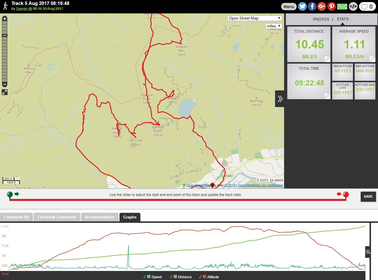
With the promise of a dry and sunny day I set off for the lakes in an optimistic mood that I’d have a good days walking up on the high fells. I made my way down to Thirlmere and parked up at Wythburn Church beside the A591, where I was pleasantly surprised to find that for the time being at least the car parking was free, rather than the extortionate £7 it would normally have been. Happy days!

Leaving the car park behind I made my way up through the forest alongside tumbling waterfalls on Comb Gill. It is a good path, pitched in many places and there is no danger of going wrong, or of getting wet feet like on my last walk. However the path is also steep, and I find myself stopping regularly to get my breath back, and also to take in the view behind me.

Looking back to Wyth Burn


Thirlmere


Harrop Tarn amidst stunning autumn colours


Looking over Steel Fell to Pike O’Blisco (left), Crinkle Crags (centre), and Bowfell (right)


The Coniston Fells


With the toughest part of the climbing now behind me I can enjoy the incredible vista to the west. This is looking over Steel Fell, High Raise and Ullscarf to the Coniston Fells, Crinkle Crags, Bowfell, Esk Pike, Scafell Pike, Great End and Great Gable. That’s some view I reckon.


The path almost levels out as I head towards the col between Helvellyn and Nethermost Pike. Up until this point I had had no view to the east, so as I approached the col I was ‘wowed’ by the view that greeted me….

Looking down into Nethermost Cove and over Eagle Crag to St. Sunday Crag


Striding Edge


Walkers on High Spying How on the western end of Striding Edge


Low Spying How at the eastern end of Striding Edge


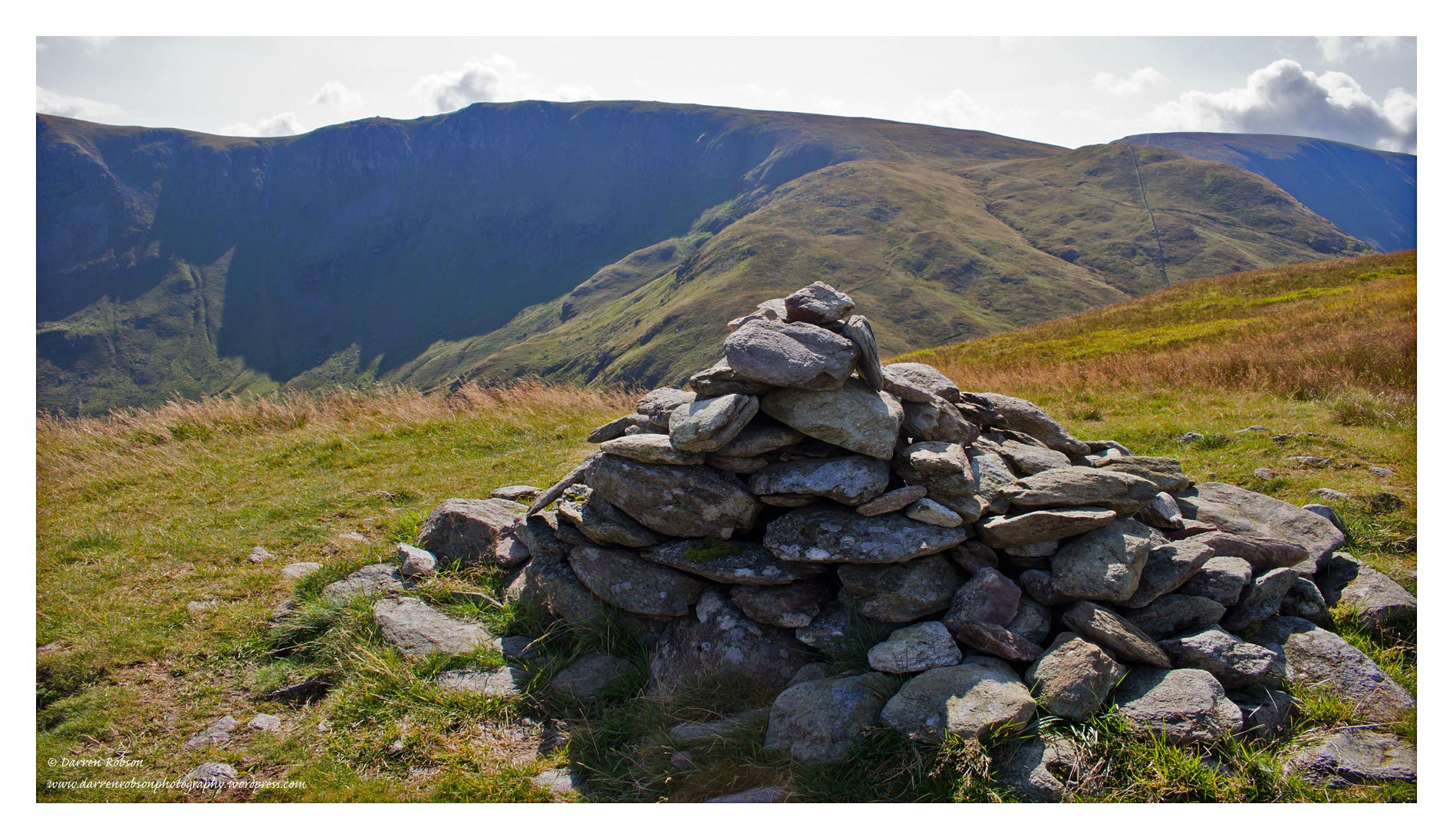
At the col instead of continuing up on to Helvellyn I take a sharp right and make the short final ascent onto the summit plateau of Nethermost Pike. The top is an extensive flat area and there are two cairns which to me appeared to be pretty much equal in height. I wasn’t sure which of them was the actual ‘highest’ point so I visited both to be sure!


This is the view I had whilst eating my packed lunch. Nice eh!


Helvellyn from Nethermost Pike


Looking down into Grisedale towards Place Fell (left), and Birks (foreground right). In the far distance is Loadpot Hill and Wether Hill, with The Nab and Angletarn Pikes mid-distance on the right.


Ill Bell, Yoke, Middle Dodd and Red Screes


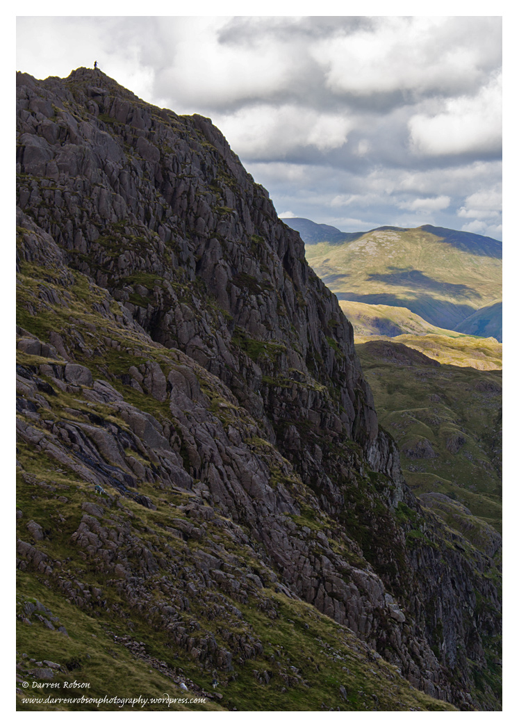
Climbers (top left) nearing the summit of Helvellyn after traversing Striding Edge. Catstycam looms large behind.


Fairfield, Dollywagon Pike and High Crag


St. Sunday Crag


Looking down over Hard Tarn to Grisedale and Place Fell, Birks and St. Sunday Crag


Midway between Nethermost Pike and Dollywagon Pike is the summit of High Crag, and this is it’s cairn. It has fantastic views but it isn’t a ‘Wainwright’.


Dollywagon Pike (left) from High Crag, with Morecambe Bay glistening in the distance


Looking over High Raise and Ullscarf to Bowfell, Esk Pike, Scafell Pike, Great End and Great Gable


In no time at all I’m on the summit of Dollywagon Pike, this is looking back to High Crag on the right


The highest point is marked by a small cairn


Fairfield from the summit cairn


A bigger cairn lies about 30 yards to the west of the highest point, this is looking over Seat Sandal to Coniston Water and the Coniston Fells


Nethermost Crag with Helvellyn and Catstycam behind


St. Sunday Crag


Great Rigg and Morecambe Bay


Fairfield over Falcon Crag


This is my favourite image of the day. Just an incredible view with huge drops directly below. Stunning scenery.


So at this point in the day I’m undecided on what to do next, I’m not sure whether to continue in a southerly direction and head for Grisedale Tarn and Seat Sandal, or retrace my steps but make a small diversion to include Helvellyn. After pondering for a few minutes I decide to leave Seat Sandal for another expedition, I figure that whilst I’m so close to Helvellyn I may as well have a look up there. It’d be rude not too!

The summit of Helvellyn – as expected it was a busy place, it seemed odd to me that I’d hardly seen a soul all day just a short distance away


Red Tarn and the summit cairn


The Ordnance Survey Column, Catstycam, Ullswater and Birkhouse Moor


The cairn at the top of Swirral Edge, with Helvellyn Lower Man (far left), Skiddaw (centre), Blencathra (distant right), and White Side (close right).


Swirral Edge and Red Tarn


Red Tarn and Striding Edge


Looking down onto Striding Edge. It’s superb to be watching the climbers crossing this awesome ridge and to remember my traverse of ‘The Edge’. The impressive backdrop is dominated by St. Sunday Crag, behind that is High Street, Gray Crag, Thornthwaite Crag and Caudale Moor.


Dollywagon Pike, High Crag and Nethermost Pike from the top of Helvellyn. So that’s it, what a superb few hours I’d had, savouring some of the finest views that the country has to offer. Now it’s time to descend back down to the car via the same path I used to come up (pictured here on the right). I was surprised to be back at the car just an hour after leaving the summit.


Branstree (2339ft, 713m) & Selside Pike (2149ft, 655m), 3rd October 2017


This circular walk begins and ends beside the road that runs alongside the eastern shores of Haweswater. The initial few hundred metres of the climb was pleasant enough, lots of recent rainfall had made the waterfalls on Rowantreethwaite Beck and Hopgill Beck very picturesque, but once away from these the climb along the North ‘Ridge’ was a dull, pathless wet trudge, it’s only saving grace was the constant view over Haweswater towards High Street. Once on the summit of Branstree I could see that the walk over to Selside Pike was going to be equally wet and bleak, and the constant stiff biting wind and potential for showers meant that I finally succumbed to donning full waterproofs. The highlight of the day was without doubt the final descent along the Old Corpse Road which gives tremendous views over the southern end of Haweswater where the flooded village of Mardale once stood.

Looking towards the Head of Riggindale and Kidsty Pike


Branstree and Harter Fell


Small Water Beck winds its way down to Haweswater surrounded by Harter Fell, Mardale Ill Bell and High Street


Blea Water beneath High Street and Long Stile


The summit of Branstree is a wet, bleak and uninteresting place and is marked only by a small pile of stones and a strange circular structure which is an Ordnance Survey trigonometrical station. This is looking towards the dome of Selside Pike and the North Pennines beyond.


Looking southwest towards Kentmere Pike


A short distance to the northeast of the summit is Artlecrag Pike with its two stone columns


Looking like something out of Lord of the Rings this is in fact a survey post which was built by the Manchester Corporation during the construction of the Haweswater Aqueduct.


Hmm. The summit of Selside Pike. A shelter. Which was good because I needed somewhere to sit and hide from the wind. A heavy rain shower can be seen in the distance but so far I’ve managed to escape the worst of the rain.


I now head northeast to meet up with the Old Corpse Road. Halfway along this part of the walk there is a nice view down into Swindale.


Swindale Common and Nabs Crag


I soon join the Old Corpse Road – and imagine what it would’ve been like in years gone by when Mardale’s dead were taken by horseback to be buried at Shap. As can be seen by the image above the weather had deteriorated somewhat by this point and it looked like I was going to get a good soaking.


However most of the showers seemed to pass me by, this image was taken 10 minutes after the one above, after the rain had cleared to the south. A couple of derelict buildings here make for some nice foreground interest.


Mardale village would once have been here


Harter Fell and Mardale Ill Bell


Waterfalls on Rowantreethwaite Beck and Branstree as I near the end of my walk


Rest Dodd (2283ft, 696m) & The Nab (1890ft, 576m), 2nd September 2017

With a good forecast for the day we set off down into the lakes to bag two more Wainwrights – Rest Dodd and The Nab, but the highlight of the day came before we’d even arrived at our destination…

As I drove towards Ullswater we passed through small patches of mist and fog, and then I suddenly noticed something I’d never seen before – a fogbow! I’ve seen pictures of them but I’d never seen one until now. What a start to the day!


This ‘white rainbow’ phenomenon forms when sunlight is reflected back to the observer through the tiny mist droplets, but because the droplets are so tiny compared to raindrops the process of diffraction broadens the reflected beam, giving a broader, often ghostly white fogbow rather than the spectrum of colours that we see in a rainbow. Incredibly cool! I love stuff like that and was really made up to see it.


Anyway back to the walk, which today begins in the tiny hamlet of Hartsop. From the car park we follow the track up towards the filter house…

Looking back from the track up to the filter house


Just beyond the filter house we cross Hayeswater Gill and join up with the main track which leads up to Hayeswater


Hayeswater and High Street


Dove Crag, Hart Crag and Fairfield over the slopes of Gray Crag and Hartsop Dodd


Hayeswater with High Street and The Knott behind


Red Screes and the Coniston fells over Hartsop Dodd


A glimpse of Ullswater from the summit of Rest Dodd


Rampsgill Head, The Knott and High Street


A short distance from the summit cairn is another cairn which gives a far better view of the fells to the west. In the foreground is Angletarn and Angletarn Pikes, while in the distance are Catstycam, White Side, Raise and Stybarrow Dodd.


Looking over Brothers Water to Dove Crag, Hart Crag and Fairfield, with Glaramara and Great Gable seen distantly on the right


Brock Crags in the foreground with St. Sunday Crag, Nethermost Pike and Helvellyn beyond


My next target – The Nab, is only 1.25 miles away but involves a very steep 650ft descent off Rest Dodd. Which of course means I have to climb back up that on my return…


The Nab, Bonscale Pike, Loadpot Hill and Wether Hill and the valley of Ramps Gill


The Nab is within the Martindale Deer Forest and is home to the oldest herd of native Red Deer in England, and I was lucky enough to have a brief encounter with some of them alongside the path – although after quickly spotting me they soon disappeared down into the valley below…


Looking back to Rest Dodd (right), The Knott (centre), and Rampsgill Head (left) from the summit of The Nab


Looking west from the summit cairn


Bannerdale and Martindale with Hallin Fell and Steel Knotts in the centre


Rampsgill Head


To avoid unnecessary disturbance to the Red Deer herd it is encouraged that all walkers stay on the path and return the same way, so a steep climb awaits back up onto Rest Dodd.


Looking over the valley of Bannerdale to Heck Crag and Angletarn Pikes with Fairfield, St. Sunday Crag, Nethermost Pike, Helvellyn and Catstycam in the distance


Once back on the summit of Rest Dodd we take the path heading west towards Satura Crag and Brock Crags (centre). Up until now we had been lucky to have had completely unbroken sunshine despite cloud forming over most of the surrounding fells during the morning. However just to show how quickly things can change up here, in the space of a few minutes we lost the warm sunshine and gained a stiff cool wind. It suddenly felt very autumnal indeed.


High Street, The Knott and Gray Crag


Hayeswater on the left as sunlight catches the slopes of Gray Crag. To the right are Caudale Moor and Red Screes


Approaching Satura Crag


Beda Fell and The Nab either side of the valley of Bannerdale


High Street and Gray Crag


Gray Crag and the wide track up to Hayeswater Reservoir. The track spoils an awesome view…


Hartsop above How and Brothers Water in the sunshine which has now made a welcome return


As we descend beneath the southern slopes of Brock Crags this is the view looking along Threshthwaite Glen to Threshthwaite Mouth and Raven Crag


Returning along the old pipeline towards the filter house with The Knott behind. From here we descend along the track we climbed earlier back to the car park.


Fellbarrow (1365ft, 416m) & Low Fell (1404ft, 428m), 15th August 2017


To the south of us the fells were shrouded in angry looking skies which moved fast across the tops, but on Fellbarrow and Low Fell the sun was out most of the time making for some impressive contrasts and moody shots.

After parking up near Thackthwaite we head west towards the foot of the fells before starting to climb up towards Fellbarrow on the old drove road. This is looking back and our first view of Crummock Water.


The heather is at its best at the moment in the lakes


Looking north from the summit of Fellbarrow


Looking west towards the Irish Sea


After leaving the summit behind we retrace our steps before heading south towards Low Fell. To the east there are tremendous views of Grisedale Pike, Ladyside Pike, Hopegill Head and Whiteside.


Approaching Low Fell


The summit of Low Fell looking towards Carling Knott, Burnbank Fell and Darling Fell


Looking back to Fellbarrow (top left)


Although the view from the actual summit is impressive enough there are better viewpoints to the south which will give even better views of Crummock Water and over Loweswater valley.


Mellbreak


The view from the cairn on the southern top


Rannerdale Knotts catches a glimpse of the sunshine but the skies are getting increasingly stormy beyond.


Loweswater with Hen Comb, Gavel Fell and Carling Knott behind


Darling Fell and the Irish Sea


Grasmoor


Lorton Vale from the steep descent off Low Fell


For the 3 hours that we’d been walking we’d still not seen the tops of High Stile and Red Pike (right). Haystacks (centre) catches a glimpse of sun.


A final look at Crummock Water before we head north through tall and dense bracken back to our starting point.


A Grand Day Out…(Final Part – Pavey Ark), 5th August 2017

We leave Sergeant Man behind and make our way on an indistinct track and yet more boggy ground to regain the wet path between High Raise and Thunacar Knott. Before reaching the top of Thunacar Knott we bear left and make a beeline for the summit of Pavey Ark…

Looking towards Windermere and Ingleborough from the summit of Pavey Ark


The Coniston Fells


Morecambe Bay and Wetherlam


The top of Pavey Ark is a very busy place with many walkers mooching about enjoying the incredible views and pleasant weather. This is looking towards Bowfell and Scafell Pike.


Harrison Stickle. Our descent will take us towards Harrison Stickle before taking the steep path down below the cliffs to Stickle Tarn below.


Looking south with Lingmoor Fell in the centre


Stickle Tarn from the path below Harrison Stickle


Pavey Ark and Stickle Tarn


Looking back up the impressive cliffs of Pavey Ark – a solitary walker on the top gives an idea of scale.


Stickle Tarn and Pavey Ark


A close-up of the cliffs and the popular climb called ‘Jack’s Rake’ seen rising at 45 degrees from right to top left. Click on the image to see it larger.


Harrison Stickle from Stickle Tarn


The steep descent from Stickle Tarn follows Stickle Ghyll all the way back down to the New Hotel at the bottom and is a stunning way to end the walk. We pass many walkers still heading up, many of whom were going to be wild camping beside the tarn. It looked like it would be a busy ‘wild’ camp for sure! With the sun now blazing down on us and the constant noise of waterfalls and water cascading over rocks I feel like there’s nowhere I’d sooner be.


With the Langdale Pikes looming above us we follow the road for just a short distance before reaching the car. Time for a well earned sit down me thinks! I’d like to say a big thank you to my brother for his company and making it such a fantastic day, it really was one of the best.


A Grand Day Out…(Part 3 – Thunacar Knott, High Raise and Sergeant Man), 5th August 2017

AW wrote that it was a ‘dull trudge’ from Harrison Stickle to Thunacar Knott. Personally speaking I don’t know that the word ‘dull’ is an appropriate way of describing any walk in the lakes as I appreciate and savour every second that I’m up amongst the fells. ‘Wet’ would be a better description as underfoot it was very boggy indeed – it was impossible to find a dry way to the top. Thankfully though it did look like we’d seen the last of the rain so with my waterproof trousers now packed away again we soon arrived at the highest point of Thunacar Knott.

Looking back to Harrison Stickle and the Coniston Fells from the highest point. Although this is the ‘highest’ point, it is not regarded as the ‘top’.


Crinkle Crags and Bowfell


The recognised summit is a shelter on a mound to the north of the highest point. So this is Wainwright number 4 in the bag. On the right of this photo is High Raise, which up until now hadn’t been on our radar. As can be seen it doesn’t look all that far away from Thunacar Knott so we look at each other and discuss the idea of now including High Raise and Sergeant Man on our walk. Certainly for my brother who lives 250 miles away the idea of bagging 2 more Wainwrights, which look temptingly close, is an appealing one. We consult my Pictorial Guide which suggests it is only a mile or so to the top of High Raise, and to include Sergeant Man as well would add about 3 miles on to the walk. The weather seems to be improving all the time and we’re both still feeling fit and up for it so we think ‘let’s do it!’ and crack on.


So after a mile of more wet-walking we arrive at the summit of High Raise. We are both super impressed at just how far we can see from here. Scotland to the north, Helvellyn and even Ingleborough to the east. Morecambe Bay to the south and the Scafells to the west.


Esk Pike, Scafell, Scafell Pike, Great End and Allen Crags


High Stile, Grey Knotts, Fleetwith Pike, Honistor Crag, Mellbreak and Robinson


Bassenthwaite Lake and Skiddaw in the distance with Sergeant’s Crag and Eagle Crag in the foreground


The North Western Fells over Rosthwaite Fell


Looking up the valley of Langstrath to the Scafells and Great Gable


From the summit of High Raise we head southeast along more wet and boggy ground to reach Sergeant Man…

The view south from the summit of Sergeant Man. Just staggering.


The Coniston Fells in the distance, with our final Wainwright of the day in the foreground – Pavey Ark.


A Grand Day Out…(Part 2 – Loft Crag and Harrison Stickle), 5th August 2017

Loft Crag and Blea Tarn


Pike O’Blisco, Cold Pike and the Coniston Fells from midway between Pike O’Stickle and Loft Crag


The summit of Loft Crag is soon reached. This is looking back to Pike O’Stickle.


Bowfell, the Scafells and Pike O’Stickle from Loft Crag. The views from the edge of the summit are truly breathtaking and the drops down into the valley below are absolutely superb – this image gives an idea of the steepness of our ascent from the valley floor up to Pike O’Stickle.


Looking towards Harrison Stickle – our next Wainwright of the day


Great Gable and Pike O’Stickle


After a short climb it doesn’t take long to reach the summit of Harrison Stickle. This is looking east towards Pavey Ark and Stickle Tarn.


Crinkle Crags, Bowfell, Esk Pike and Great End


Looking towards Blea Tarn and the Coniston Fells


From the southern edge of the summit there is a superb view looking over the deep ravine of Dungeon Ghyll to Pike O’Blisco, Cold Pike and Crinkle Crags


Crinkle Crags and Bowfell dominate the horizon


Morecambe Bay, Blea Tarn and Wetherlam


Helvellyn, Nethermost Pike, Dollywagon Pike, St. Sunday Crag and Fairfield on the horizon with Steel Fell catching the sunshine mid-distance.


In the distance St. Sunday Crag, Fairfield, Hart Crag, Great Rigg, Dove Crag and High Street can all be seen clearly as the visibility is just superb. Walkers can be seen on the summit of Pavey Ark, this will be our final and 7th Wainwright of the day, But first we head north to Thunacar Knott – ‘a dull trudge’ as AW puts it!


Thunacar Knott (in the sunshine in the centre), with High Raise to the right. High Raise and Sergeant Man weren’t part of our original itinerary but once we’d quickly reached Thunacar Knott we decided that it would be daft not to include them!


A Grand Day Out…(Part 1 – Pike O’Stickle), 5th August 2017

My brother and his family were staying in Keswick for the week so with a decent weather forecast we teamed up for our now annual ‘Grand Day Out’ in the fells. Today really was a superb day, with no less than 7 Wainwrights bagged in this full day’s yomp around the fells. Our route took us from Dungeon Ghyll and along Mickleden to:

  • Pike O’Stickle (2326ft, 709m)
  • Loft Crag (2231ft, 680m)
  • Harrison Stickle (2415ft, 736m)
  • Thunacar Knott (2372ft, 723m)
  • High Raise (2500ft, 762m)
  • Sergeant Man (2395ft, 730m)
  • Pavey Ark (2297ft, 700m)

I figured it would be easier to post all the images in a few parts as there are so many!


The distinctive shape of Pike O’Stickle makes it a familiar landmark for miles around. This is taken from the valley floor of Mickleden as we make our way towards Troughton Beck.


Walking along Mickleden with Rossett Pike in the centre catching a tiny patch of sun. As it turned out the weather forecasters got it completely wrong yet again – instead of a dry day with a chance of a shower later we were soon putting on our waterproof jackets and trousers. The steep climb up alongside Troughton Beck wasn’t particularly pleasant at all actually as the heavy rain lashed down on us, and we became a little bit concerned in case this was how it was going to be all day. Up to our right we could see that our first Wainwright of the day, Pike O’Stickle, had now disappeared in the cloud and rain.


Looking back from half way up Troughton Beck to Mickleden and Pike O’Blisco


Esk Pike and Great End over Rossett Pike


Pike O’Blisco and Cold Pike


With the steepest part of the ascent done it’s time to enjoy the views. This is looking over our climb towards Bowfell and Rossett Gill


Great End, Allen Crags and Great Gable appear over Rossett Pike


The worst of the rain has now passed and thankfully we can see Pike O’Stickle again. This is looking towards the summit after joining up with the path from Stake Pass. The final climb involves a bit of scrambling and the drops down to our right are very impressive!


Awesome views down below us as we scramble up to the top


The summit of Pike O’Stickle looking southeast over Loft Crag towards Windermere and Blea Tarn


Bowfell, Esk Pike, Great End, Allen Crags and Great Gable from the summit


The Coniston Fells over Pike O’Blisco and Cold Pike


Harrison Stickle and Loft Crag


The light is fantastic now that the rain has passed through and the sun begins to make an appearance. This is Great End, Allen Crags and Great Gable.


But it looks very wet towards Keswick and Skiddaw!


Soon after the rain the visibility is excellent and we can see as far as Morecambe Bay


Rosthwaite Fell (left), Grange Fell (centre), and Sergeant’s Crag in sunshine (right)


Our next target – Loft Crag


Short Break in Fort William, 25th-28th July 2017

Here’s a selection of my favourite shots taken during a recent short break exploring the Glen Coe, Fort William and Glenfinnan areas. We certainly saw some big changes in the weather during our stay, our first day was hot and sunny, this was then followed by two days of heavy showers, before torrential rain on our final day. It was fascinating to see the changes in the scenery during our visit, there had been hardly any rainfall for the 2-3 weeks prior to our arrival (bloody typical!), so this meant that all of my planned waterfall shots were a waste of time because there was barely any water in the rivers! But the torrential downpours whilst we were there meant that by the time we left all the mountains and rivers took on a totally different appearance to how they had looked upon our arrival…


Dawn (0420hrs) over Rannoch Moor


The River Coupall winds its way past Lagangarbh Hut with Buachaille Etive Mor on the left and Buachaille Etive Beag on the right. Even though it turned out to be a largely sunny day the cloud stubbornly refused to budge from the summits of these mountians.


‘The Three Sisters of Glen Coe’  bathed in early morning sunshine. Beinn Fhada, Gearr Aonach and Aonach Dubh.


Gearr Aonach – the middle one of ‘The Three Sisters of Glen Coe’


A shaft of sunlight appears over Aonach Dubh and lights up Achnambeithach Cottage


Truly breathtaking scenery. A stunning waterfall backed by Stob Coire nam Beith


‘The Jacobite’ hauled by steam loco Black Five 45212 passes alongside Loch Eil at Corpach


Now 68 years old, K1 62005 waits at Fort William with the morning ‘Jacobite’ train to Mallaig.


We spent some time around the famous Glenfinnan Monument and Glenfinnan Viaduct, trying to capture the steam trains as they passed over this impressive structure. This is a beautiful area to explore, but it’s also particularly popular with tourists from all over the world who come to see the ‘Hogwarts Express’ made famous in the Harry Potter film. So instead of enjoying this sight by ourselves we were joined by literally hundreds of people and thousands of midges who gathered on the hillsides to take pictures (the people, not the midges)…


Glenfinnan Monument and Loch Shiel


On one afternoon we were lucky enough to travel on ‘The Jacobite’. This is our driver in the cab of the Black 5 waiting in the rain at Fort William. It’s unbelievable to think that this loco is now 82 years old and still in superb working order slogging to Mallaig every day.


On the shores of Loch Eil at Corpach is this wreck which makes a nice foreground subject with the mighty Ben Nevis towering behind.


A gloomier day with stormy skies meant I was able to use a slightly longer exposure which blurs the movement of the waves on the shore.


Because it was such a short break and because we were trying to cram in as much as possible we only had time for one walk – the climb up through the Nevis Gorge to the superb Steall Falls. But what a walk! One of the best short walks in Scotland apparently. And I can see why…

Hmm cheers! This sign really filled us with confidence at the start of the walk!…


The Nevis Gorge is indeed impressive with some big drops on one side of the path down into the river far below, but once safely negotiated we emerge out of the gorge and clap eyes on the awesome Steall Falls for the first time.


Steall falls is Scotland’s second highest waterfall at a height of 120 metres


Looking back to the Nevis Gorge and Carn Dearg, with the slopes of Ben Nevis to the right


A short drive up behind Fort William leads to a viewpoint with good views over to the western face of Ben Nevis.


A close up view of Ben Nevis and the mountain path that leads to the summit


Stormy skies over the Pap of Glencoe and Loch Leven


Loch Leven and the Pap of Glencoe


Clachaig Falls with the west face of Aonach Dubh towering behind


Aonach Dubh looking very different to how it did when we arrived a few days earlier!


‘The Study’, a popular viewpoint looking down The Pass Of Glen Coe


Lagangarbh Hut with Buachaille Etive Mor behind


Buachaille Etive Mor


The last photograph of the trip. Unbelievably the two waterfalls that are the main focus of this image were both bone dry when we arrived – the only water was flowing over the rocks on the far left of this image. Despite the heavy rain I was most surprised to be able to see the actual top of this iconic mountain.